Catchment models
We build a reliable numerical model of a catchment and its sub-catchments, assessing flood and low-flow regimes of watercourses and the effects they produce on the surrounding area.
Efficient water management and a safer territory.
We study the behaviour of surface water and groundwater to ensure efficient management of water resources, environmental protection and a safer territory.
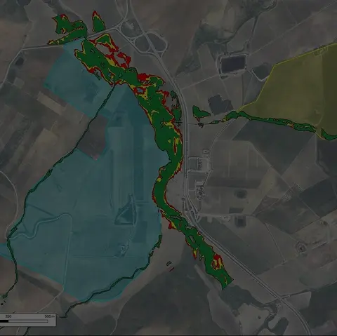
We build a reliable numerical model of a catchment and its sub-catchments, assessing flood and low-flow regimes of watercourses and the effects they produce on the surrounding area.
With 1D and 2D hydraulic modelling we analyse flood-prone areas and assess local hydraulic risk, the basis for structural works or water-regulation measures consistent with land planning.
We verify the hydraulic invariance of land-use changes and size the drainage and attenuation works needed to manage water safely.
01/05
You tell us about the project: we review requirements, constraints and the documents available.
We define the site and laboratory investigations best suited to the works and the regulations.
We run in-situ, geophysical and laboratory tests with our own instruments.
We turn the data into geological, geotechnical and hydraulic models to NTC 2018.
We deliver clear reports and drawings for every design stage.
Reliability and experience allow us to tackle geological, environmental and engineering problems with a high degree of complexity.
Excellent
Based on 7 reviews

Valentin Sarmasan
Servizio professionale ma con un approccio umano. Sempre disponibili al confronto.

Maria Pia Tarantino
Azienda che si distingue per professionalità e praticità. Laboratorio serio ed organizzato con strumentazione moderna. Un punto di riferimento nel settore della geologia.

Rosa Martucci
Mi hanno dato un supporto concreto e utile, senza complicare inutilmente le cose.

Domenico Calderoni
Ho avuto un’ottima esperienza con Geotechnology 4.0. Il team si è dimostrato estremamente competente, preciso e sempre disponibile al confronto. Il lavoro è stato svolto con grande professionalità e attenzione ai dettagli tecnici. Tempistiche rispettate e comunicazione chiara in ogni fase. Consigliata a chi cerca un supporto affidabile e di alto livello nel settore geologico, geotecnico e geofisico.

Arianna Grimaldi
Ho contattato Geotechnology 4.0 per chiedere un preventivo e sono rimasta davvero sorpresa dalla rapidità e dalla disponibilità. In soli tre giorni dalla richiesta, il team si era già organizzato per andare in cantiere e iniziare le prime verifiche e gli studi necessari

Alessandro Leone
Professionisti preparati ma soprattutto molto pratici. Sanno andare dritti al punto senza perdere tempo. Ho apprezzato soprattutto la loro immediata disponibilità

lavrenti jimsheris asuli
Studio affidabile e ben organizzato. Hanno rispettato tempi e accordi, cosa non scontata ad oggi. Inoltre ho trovato molta disponibilità, gentilezza e professionalità
Fill in the form with the details and an outline of the service you need: one of our managers will contact you as soon as possible.
Mobile
+39 327 4999574